Search by category, route or point of interest

Routes and points of interest Agenda and events Online Store Information of Interest contact
English
  • català
  • español
  • français

Filter routes

Sport

hiking

Trail Running

Skimo

Road bike

Mountain bike


Land

The terrain is determined by distance, positive slope and terrain.

Track routes, trails or obvious traces in low or medium mountains.

Routes in medium or high mountain terrain without technical steps.

Routes in medium or high mountain terrain with technical climbing steps.


Route distance

1.43 km - 35.89 km

route gradient

142 m - 2187 m

Duration approx. of the route

0 - 13h
Reset filters

Filter Points of Interest

Category

Reset filters
Show the list

Itinerari de la pedra seca

demanding
Favorite
Mur de pedra seca. Tècnica:
S’entén per pedra seca la tècnica constructiva en la que s’uneixen pedres i pedruscall sense utilitzar cap morter d’unió, col·locant el material de tal forma que quedi fixat per si sol. A vegades s’utilitza sorra en sec per omplir els buits i l’interior de la paret, esdevenint maçoneria de morter de terra.
La construcció de pedra seca es caracteritza per adaptar-se perfectament al terreny i a les necessitats de cada moment, aprofitant sàviament les oportunitats que brinda la naturalesa. Des del neolític, fins el segle XX ens dona una llarga tradició de continuïtat. En aquesta clariana tenim l'oportunitat de veure juntament el poble de la Massana, el d'Escàs i el de Sispony, amb el pic de Carroi al fons a l'esquerra.
Magnifiques vistes al Pic de Casamanya des de la Gonarda. Camí del Roc de la Gonarda.
Show +5 photos

distance · 1,4 Km
duration · 0h 40min
Elevation Gain · + 159
Circular · No

General Description

Al llarg d'aquest itinerari recorreràs zones boscoses i urbanes, on podràs observar edificacions de diferents èpoques fins a l'actualitat. Et demanem, però, que et fixis en les construccions més modestes. Construccions, que malgrat la seva simplicitat, han resistit el pas dels segles i són avui part del nostre Patrimoni Cultural i Natural: les construccions en pedra seca. Des de temps immemorials, els habitants d'Andorra han emprat allò que la muntanya els donava en abundància, la pedra, per elevar murs i domesticar el paisatge. Les tarteres d'Andorra han proveït d'una excel·lent matèria primera a la població d'aquestes valls, que han utilitzat la pedra que n'extreien per realitzar construir orris, bordes, feixes, camins i carboneres. Construccions vinculades a les activitats agrícoles i ramaderes, i més tard també a la metal·lúrgica, que intervenen el paisatge des del màxim respecte per la natura, sense utilitzar cap més element que no sigui la pedra mateixa. La pedra seca és un símbol del nostre país. Vestigi d'un passat on l'home i la natura vivien en equilibri. Llegat per un futur fidel a les nostres arrels. Completa el repte Cub a Cub de la Massana amb la informació que trobaràs als cubs del camí.


Turisme la Massana Comú de la Massana
Report incidence
Mostra el llistat Mostra el llistat
​

Safety tips

Enjoy the mountain safely

Mountain tours can be dangerous, which is why it is your responsibility to take all the necessary measures to safeguard your safety and integrity.

1. Preparation of the itinerary

Check the weather forecast before your departure

Take into account your physical condition and your experience in the environment

Consult the avalanche danger bulletin in winter times

Plan a suitable route knowing shelter points

2. Essential material

Bring the appropriate material for the activity and weather conditions

The rucksack cannot lack drink and food adapted to the departure

Don't forget to check beforehand that the DVA, Shovel and Probe are working

3. Mountain rescue

In the event of an accident or rescue in the mountains, call the emergency number.

112

The information and/or data set out on this page are not binding, although they may guide you during your journey. However, said information and/or data will not replace the need for experience, training and/or the support of a professional when organizing your tour. Therefore, this page will not be responsible for safeguarding its security and integrity during its journey.

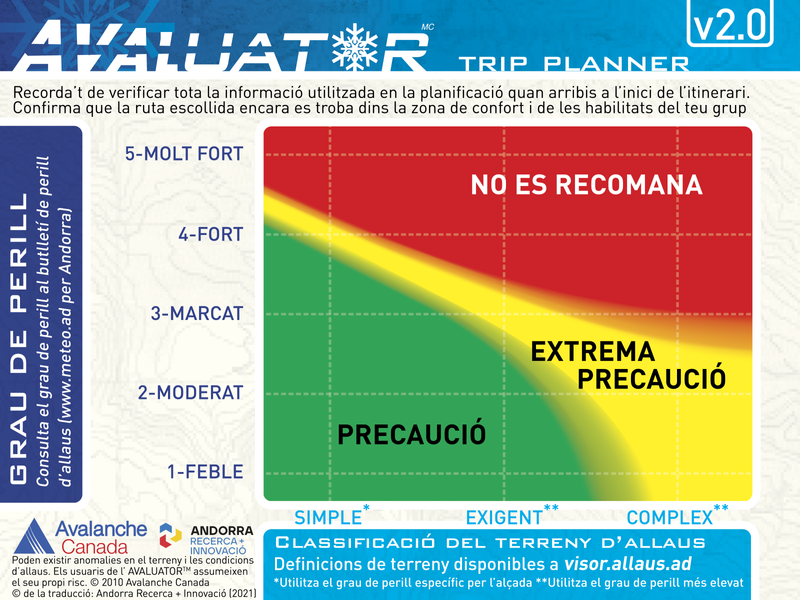
evaluator

What is ATES mapping?

The Avalanche Terrain Exposure Scale (ATES by its acronym in English) is a tool that allows you to evaluate, describe and communicate how prone the terrain is to being affected by avalanches, without taking into account variable snow-meteorological factors.

The ATES classification was developed in 2004 by Parks Canada following an accident in which seven teenagers died, probably due to a bad choice of route. Since then, this scale has been applied to several mountain ranges in Canada and New Zealand.

In the Pyrenees, this project has been developed in the Lauegi Center of Aran, in Tavascan, in some sectors of the Aragonese Pyrenees and in Andorra.

To carry out this classification, the technicians take into account different variables such as the slope, the density of the vegetation, the traps in the terrain or the frequency and size of expected avalanches, among others.

The final product is an invariant map in which the alluvial terrain is divided into three classes.

evaluator
What are the types of terrain?
Simple

Exposure to steep slopes and forest terrain. Some forest clearings may involve areas of infrequent avalanche arrivals. Many options to reduce or eliminate exposure

demanding

Exposure to well-defined avalanche path zones, exit zones or traps. There are options to reduce or eliminate exposure by careful route finding

Complex

Exposure to multiple and overlapping avalanche path zones or to large areas of open and sloping terrain. Multiple avalanche start zones with traps below. Minimal options to reduce exposure

For more information visit the website allaus.ad a project of Andorra Research + Innovation