Search by category, route or point of interest

Routes and points of interest Agenda and events Online Store Information of Interest contact
English
  • català
  • español
  • français

Filter routes

Sport

hiking

Trail Running

Skimo

Road bike

Mountain bike


Land

The terrain is determined by distance, positive slope and terrain.

Track routes, trails or obvious traces in low or medium mountains.

Routes in medium or high mountain terrain without technical steps.

Routes in medium or high mountain terrain with technical climbing steps.


Route distance

1.43 km - 35.89 km

route gradient

142 m - 2187 m

Duration approx. of the route

0 - 13h
Reset filters

Filter Points of Interest

Category

Reset filters
Show the list

Itinerari de la biodiversitat

demanding
Favorite
El Riu Pollós, format principalment per la unió del riu de Comapedrosa i el riu del pla de l'Estany, s'inclou a la xarxa hidrogràfica de la vall d'Arinsal, afluent de la conca del Valira del Nord. Com la resta de rius pirinencs, té un règim característic amb crescudes fortes a la primavera (desglaç), i dos períodes d'estiatge, un a la darreria de l'estiu i un altre a l'hivern.
Les aigües d'aquest curs fluvial, fredes, netes i ben oxigenades, permeten la presència d'espècies animals molt interessants. Aquest és el cas de la truita comú, del tritó pirinenc i de l'aigüerola. Berenador i Font del Riu Pollós
Pista del Pla de l'Estany Borda de Moixó.
Valls del Comapedrosa Bordes de la Coruvilla. Pista del Pla de l'Estany Canal de l'Alt de Comapedrosa El refugi del Pla de l’Estany es va inaugurar l’any 1981 i té una estança privada només per als pastors i forestals i una altra d’oberta al públic, petita però acollidora, amb lliteres, taula, llar de foc i bancs. Hi ha una font d’aigua a uns 20 metres del refugi. Camí corriol del Pla de l'Estany
Show +12 photos

distance · 6 Km
duration · 3h 44min
Elevation Gain · + 896
Circular · Si

General Description

En aquest itinerari visitaràs el Parc Natural del Comapedrosa, una zona de gran valor natural. Si pares bé l'orella, al final de l’itinerari, potser sentiràs alguna de les marmotes que hi viuen. Des d'aquí arribaràs fins al refugi del Pla de l'Estany, on si vols, pots fer-hi nit. El Parc Natural Comunal de les Valls del Comapedrosa compta amb una àrea protegida de 1.540 hectàrees, l'equivalent a més de 1.400 camps de futbol. Aquí hi trobareu el cim més alt d'Andorra, el Comapedrosa, de 2.942 metres d'altura. Un terreny prou gran i amb prou desnivell per a comptar amb gran diversitat d'espècies de fauna i flora. És justament per conservar aquesta biodiversitat, que el parc ha desenvolupat un programa de seguiment on s’analitza l’estat de les diferents comunitats animals i vegetals. Algunes d’aquestes espècies són, a més bio indicadores: organismes, que per la seva abundància i característiques fisiològiques, reflecteixen l'estat de conservació del medi ambient i dels hàbitats naturals. El seguiment d'aquestes espècies, amb la comparació anual de les seves poblacions, ens permet avaluar la qualitat de l'aire i de l'aigua i detectar la possible presència de contaminants. Dins d'aquestes espècies bio indicadores, les papallones diürnes són un grup especialment sensible i com a tal s'inclouen a la xarxa de seguiment Butterfly Monitoring Scheme d'Andorra (BMSAnd). La proliferació d'espècies adaptades a climes més càlids contra la regressió de les espècies més adaptades a climes freds són indicadors que mostren les conseqüències del canvi climàtic, així com la proliferació d'espècies amb menys requeriments hídrics podria indicar l'impacte de situacions de sequera. Les dades obtingudes al Parc del Comapedrosa, així com en altres zones naturals del país, s'integren dins el monitoratge europeu de la xarxa BMS, que ja ha permès establir alguns efectes del canvi climàtic. L'activitat humana té incidència directa sobre l'estat de conservació de la biodiversitat que t'envolta. Respecta la flora i fauna del Parc, circula només per la xarxa de camins senyalitzats i utilitza els llocs autoritzats per dipositar la brossa. Completa el repte Cub a Cub de la Massana amb la informació que trobaràs als cubs del camí.


Turisme la Massana Comú de la Massana
Report incidence
Mostra el llistat Mostra el llistat
​

Safety tips

Enjoy the mountain safely

Mountain tours can be dangerous, which is why it is your responsibility to take all the necessary measures to safeguard your safety and integrity.

1. Preparation of the itinerary

Check the weather forecast before your departure

Take into account your physical condition and your experience in the environment

Consult the avalanche danger bulletin in winter times

Plan a suitable route knowing shelter points

2. Essential material

Bring the appropriate material for the activity and weather conditions

The rucksack cannot lack drink and food adapted to the departure

Don't forget to check beforehand that the DVA, Shovel and Probe are working

3. Mountain rescue

In the event of an accident or rescue in the mountains, call the emergency number.

112

The information and/or data set out on this page are not binding, although they may guide you during your journey. However, said information and/or data will not replace the need for experience, training and/or the support of a professional when organizing your tour. Therefore, this page will not be responsible for safeguarding its security and integrity during its journey.

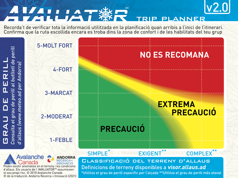
evaluator

What is ATES mapping?

The Avalanche Terrain Exposure Scale (ATES by its acronym in English) is a tool that allows you to evaluate, describe and communicate how prone the terrain is to being affected by avalanches, without taking into account variable snow-meteorological factors.

The ATES classification was developed in 2004 by Parks Canada following an accident in which seven teenagers died, probably due to a bad choice of route. Since then, this scale has been applied to several mountain ranges in Canada and New Zealand.

In the Pyrenees, this project has been developed in the Lauegi Center of Aran, in Tavascan, in some sectors of the Aragonese Pyrenees and in Andorra.

To carry out this classification, the technicians take into account different variables such as the slope, the density of the vegetation, the traps in the terrain or the frequency and size of expected avalanches, among others.

The final product is an invariant map in which the alluvial terrain is divided into three classes.

evaluator
What are the types of terrain?
Simple

Exposure to steep slopes and forest terrain. Some forest clearings may involve areas of infrequent avalanche arrivals. Many options to reduce or eliminate exposure

demanding

Exposure to well-defined avalanche path zones, exit zones or traps. There are options to reduce or eliminate exposure by careful route finding

Complex

Exposure to multiple and overlapping avalanche path zones or to large areas of open and sloping terrain. Multiple avalanche start zones with traps below. Minimal options to reduce exposure

For more information visit the website allaus.ad a project of Andorra Research + Innovation